Climate-resilient infrastructure in Bangladesh
Bangladesh is one of the world’s most vulnerable countries to climate hazards. Both sudden hazards, such as cyclones and monsoonal flooding, as well as gradual hazards, such as saline intrusion and sea-level rise, continuously impact the local population. Infrastructure systems provide basic services to society, enhancing socio-economic growth through transport connectivity, access to health and education, and clean water, amongst others. The country’s high exposure to climate hazards means that these services are repeatedly disrupted, limiting Bangladesh’s progress towards the Sustainable Development Goals (SDGs) and longer-term climate resilience.
Our recent geospatial analysis of climate-resilient infrastructure in Bangladesh builds on existing initiatives in Bangladesh and aims to quantify the impact of climate hazards on the provision of infrastructure services across the country. Then we zoom into the coastal area of Bangladesh, where we use a new, high-resolution spatial household dataset developed by the World Bank [1], which associates demographic and poverty information about households with the locations of houses in which they are likely to live. This high-resolution dataset enables us to take a closer look at how climate-related disruptions in infrastructure services affect households differently, and how this impacts overall progress towards achieving the SDGs. We use well-established methodologies from the OPSIS group to undertake the analyses in this project.
Our findings show the extent to which infrastructure assets and networks in Bangladesh are highly exposed to the climate hazards of riverine flooding, coastal flooding, cyclonic winds, and erosion. Our analyses produced extensive results across many future climate scenarios, but some of the key findings include:
- Coastal flooding is the most impactful hazard on the transport sector (Figure 1), resulting in estimated damages of up to €7.4 billion for the year 2050, due to damages in the road network alone.
- Cyclonic winds have the greatest impact on the energy sector, particularly the electricity grid with its overhead transmission and distribution lines (Figure 1). At the national scale, economic damage of cyclones to the electricity grid could affect up to 145 million people in Bangladesh in 2050, serving 88% of the national population.
- With regard to critical social infrastructure, we find that 95% of healthcare facilities, 70% of cyclone shelters, 93% of market centres, and 95% of education facilities are currently exposed to climate hazards in Bangladesh, potentially affecting the delivery of key social and economic services.
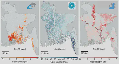
Figure 1: Examples of infrastructure exposure to different hazards. Left: road network exposed to coastal flooding; Middle: electricity grid exposed to cyclonic winds; and, Right: education facilities exposed to river flooding.
When we zoom into the coastal region and start unpicking how such infrastructure service disruptions affect the population differently, we see that there are over three times more rural households affected by infrastructure service disruptions than urban households, and the poorest portions of the population are most significantly impacted. Overall, 76% of the nearly 9 million households are affected by infrastructure disruptions caused by one or more hazards, with the most common hazard combination being cyclones and their associated storm surges. The south-western coastal area of Bangladesh stands out as the area experiencing the largest variety of hazards, with five upazilas (small administrative regions) especially standing out, as shown in Figure 2.
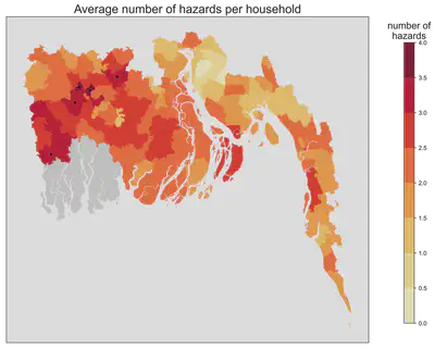
Figure 2: Average number of hazards a household experiences, aggregated to the upazila scale When combining all hazards and all infrastructure assets and networks, we see three key upazilas where households experience disruptions to ten asset types (electricity substations, railway stations, inland water terminals, education facilities, market centres, health facilities, cyclone shelters, the electricity grid, gas lines, and roads) (Figure 3). These are Bagerhat Sadar, Chandpur Sadar, and Cox’s Bazar Sadar. The colour scale shows the number of different assets across all sectors which are exposed to hazards, and the size of the marker represents the cumulative number of households dependent on the disrupted assets.
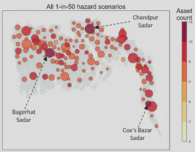
Figure 3: Number of assets and cumulative number of households affected by all hazards
We also connect this spatial understanding of household-level socio-economic characteristics and access to infrastructure services (e.g., roads, education facilities, healthcare facilities, cyclone shelters, amongst others) to Bangladesh’s development vision through the achievement of relevant SDG indicators. We identified six relevant SDG indicators for this project, representing SDGs 3 (good health and wellbeing), 4 (quality education), 7 (affordable and clean energy), 8 (decent work and economic growth), 9 (industry, innovation, and infrastructure), and 13 (climate action). Knowing where relevant SDG indicators are underperforming allows us to understand how and where climate-related disruptions to infrastructure service provision can risk progress towards sustainable development.
Figure 4 combines all hazards and illustrates the overall progress at risk in achieving each of the six relevant SDG targets, for each coastal district. The maps here emphasise the previous findings of the south-western coastal districts being most impacted; the Satkhira and Khulna districts (highlighted in the red box for SDG 13) are most likely to experience a halting or reversing of achieving infrastructure-related SDGs by 2050 due to the high exposure of key assets to different climate hazards, as well as low levels of current SDG progress. In order to ensure localised progress towards full achievement of Bangladesh’s national SDG agenda, the Government of Bangladesh need to target its adaptation responses where climate threats to progress on priority indicators are most likely, and where impacts are felt by the most vulnerable populations.
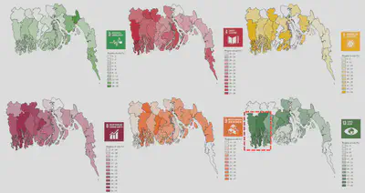
Figure 4: Summary of progress at risk for each of the six relevant SDG targets. Progress at risk refers to how climate hazards cause disruptions in infrastructure provision to households, affecting their overall progress for sustainable development.
Written by Amelie Paszkowski, on behalf of the project team comprising Sarah Gall, Mohammed Sarfaraz Gani Adnan, Alison Peard, and Dan Adshead.
We acknowledge the many institutions who made the project possible, including:
- Global Centre on Adaptation for funding the project and providing guidance along the way.
- United Nations Office for Project Services (UNOPS) for coordinating the project amongst all stakeholders and undertaking the enabling environment component of the project, ensuring that it has the potential to be integrated into the current planning landscape of Bangladesh.
- Centre for Environment and Geographic Information Services (CEGIS) for providing data on infrastructure assets and networks for Bangladesh and sharing in-country expertise.
- The World Bank for providing the high-resolution synthetic household dataset for the coastal region of Bangladesh.
- Data providers and key stakeholders: MoEFCC, WARPO, LGED, SREDA, BWDB, RHD, CreLIC, BPDB, BREB, Power Cell, among others) and development partners (World Bank, Asian Development Bank, among others).
[1] Rubinyi, S., Verschuur, J. and Hall, J.W. High-resolution synthetic population mapping for quantifying disparities in disaster impacts: an application in the Bangladesh Coastal Zone, Frontiers in Environmental Science, in review.